Architectual.Gravitas
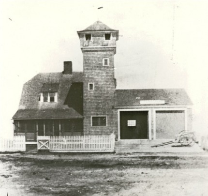
The Hog Island Life-Saving Station was commissioned in 1875. This photograph is of the 2nd of a total of five different stations to be erected on the island. This station responded to twenty-four major shipwrecks. The Keeper and surfmen of the Hog Island station received the Gold and Silver Life-Saving Medals for their heroic efforts at the scene of the shipwreck San Albano, in 1892.
History of Shipwrecks and Rescues
- Delmarva WrecksWreck Of The Italian Ship Fortuna
- Read the full story.
- Get the printable version. -->Shipwreck of the Red Wing
- Read the full story.
- Get the printable version. -->The Wreck of the Sallie W. Kaye
- Read the full story.
- Get the printable version. -->Shipwreck of the British Bark, Syringa
- Read the full story.
- Get the printable version. -->Shipwreck of the Spanish Steamship, San Albano
- Read the full story.
- Get the printable version. -->Shipwreck of the Norwegian Bark, Lena
- Read the full story.
- Get the printable version. -->Shipwreck of the Albert Dailey
- Read the full story.
- Get the printable version. -->The Blizzard of March 1888
- Read the full story.
- Get the printable version. -->The Great Storm of 1889
- Read the full story.
- Get the printable version. -->The Wreck of the Luther A. Roby
- Read the full story.
- Get the printable version.
- -->The Wreck of the William B. Woods
- Read the full story.
- Get the printable version. -->The Wreck of the Sloop Dauntless
- Read the full story.
- Get the printable version. -->The Wreck of the Pendleton Sisters
- Read the full story.
- Get the printable version. -->The Wreck of the Margaret A. May
- Read the full story.
- Get the printable version. -->The Wreck of the Hannah M. Lollis
- Read the full story.
- Get the printable version. -->The Wreck of the Laura Tompkins
- Read the full story.
- Get the printable version. -->The Stranding of the Bark Maddalena Secondo
- Read the full story.
- Get the printable version.
Big Ship Stranded Near Ocean City
at Indian River Inlet, Delaware 1891
At Ocean City, Maryland, 1883
Green Run Station, Maryland
Hog Island Station, Virginia
Hog Island Station, Virginia
Smith Island Station, Virginia
At Cape Henlopen, Delaware
At Rehoboth, Delaware
Lewes, Delaware 1896
At Chincoteague, Virginia, 1882
Metomkin Island, Virginia,1882
At North Beach, Maryland, 1884
At Pope’s Island, Virginia 1892
At Cobb’s Island, Virginia, 1913
At Cedar Island, Virginia 1882
- Fifty Rescued at Green Run Inlet, 1883
- Read the full story.
- Get the printable version. -->Other Notable WrecksShipwreck of the British Schooner, Mizpah
- Read the full story.
- Get the printable version. -->Shipwreck of the Canadian Schooner, Ariadne
- Read the full story.
- Get the printable version. -->Shipwreck of the Fannie A. Bailey
- Read the full story.
- Get the printable version. -->Shipwreck of the George D. Sandford
- Read the full story.
- Get the printable version. -->Shipwreck of the J. O. Moss
- Read the full story.
- Get the printable version. -->Shipwreck of the Schooner, D. H. Ingraham
- Read the full story.
- Get the printable version. -->Shipwreck of the Schooner, Eclipse
- Read the full story.
- Get the printable version. -->Shipwreck of the Schooner, Frances
- Read the full story.
- Get the printable version. -->Shipwreck of the Schooner, Jessie Martin
- Read the full story.
- Get the printable version. -->Shipwreck of the Steamer, Argo
- Read the full story.
- Get the printable version. -->Shipwreck of the Steamer, Czarina
- Read the full story.
- Get the printable version. -->Shipwreck of the Steamer, Louis Pahlow
- Read the full story.
- Get the printable version. -->Shipwreck of the Whaling Bark, ATLANTIC
- Read the full story.
- Get the printable version. -->Stranding of the Steamer, F. and P. M., No. 1
- Read the full story.
- Get the printable version. -->Wreck of a Skiff
- Read the full story.
- Get the printable version. -->Wreck of a Steam-Launch
- Read the full story.
- Get the printable version.
Green Run, Maryland
Peaked Hill Bar Station, Cape Cod, Massachusetts
Mexico Bay, Lake Ontario, New York
Hereford Inlet Station, New Jersey
Manistee Life-Boat Station, Manistee, Michigan
Grand Point au Sable Station, Michigan
Hereford Inlet Station, New Jersey
Grand Point au Sable Station, Michigan
Big Kinnakeet Station, North Carolina
Grand Haven Station, Michigan
Tillamook Bay Station, Oregon
Coos Bay Station, Oregon
Sturgeon Bay Canal Station, Michigan
San Francisco, California
Ludington Station, Michigan
Falls of the Ohio River, Louisville Station, Kentucky
Chicago Station, Illinois
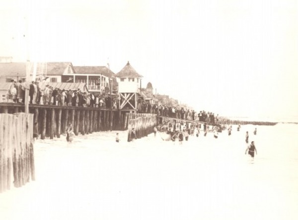
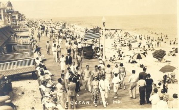
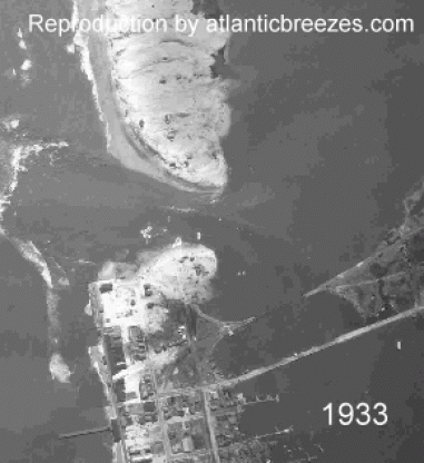
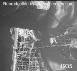
- This idyllic scene was destroyed by a violent hurricane in 1903. Abruptly, development ceased in the south-end of Ocean City.
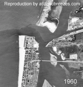
- This same area was again destroyed 30 years later during the Hurricane of August 1933 which formed the present day Ocean City Inlet.
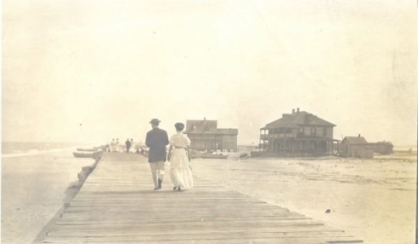
1903
A well-remembered scene in Ocean City was fish monger Hazzard Taylor in 1910.
He was always a welcome sight to everyone in town. Fresh fried fish was a staple on Ocean City menus.

1910
A ride on an oxen-drawn cart was a pleasurable treat for those who vacationed at Ocean City.
This 1912 photograph shows guests of the Belmont Hotel enjoying a ride along the surf.
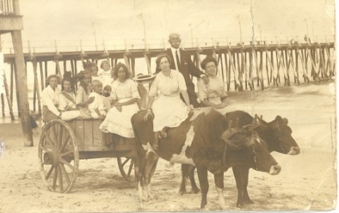
1912
- Collection of the Ocean City Museum Society Inc. -
Considered a sportsman’s paradise, the beaches and back bays of Ocean City were a magnet to wildfowl hunters.
Some of the wealthiest men in America used these humble gunning shanties as shelter in their pursuit of ducks and geese.
Captain J. W. Quillin made a fine living and many important social connections as a hunting guide. (This was a 1926 Worcester County, Maryland tourism advertisement.)
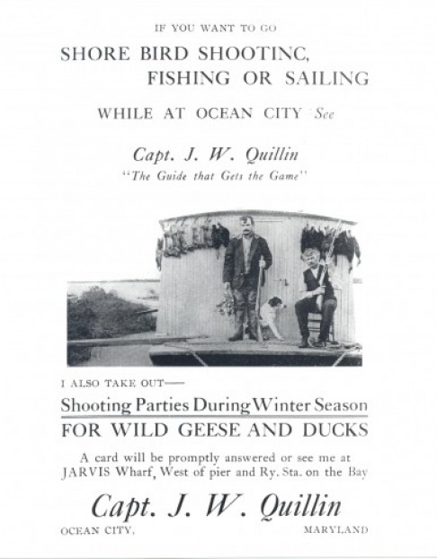
1926
There was no beach to speak of during the early 1930s. The ocean often spilled onto the side streets and flooded Baltimore Avenue. Note the height of the boardwalk in those days and the large crowd gathered to watch the adventurous swimmers.
1930s
Ruth Phillips Meeker of Cambridge, Maryland poses on the beach at Ocean City in 1931. She, incidentally, lived to be more than 100 years old.
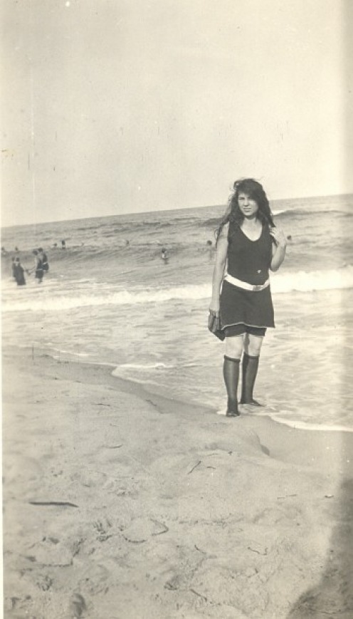
1931
Collection of Virginia Ayres Satterfield
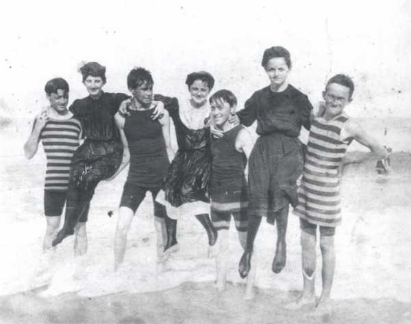
Dressed in the bathing fashion of the day, the John J. Ayres family frolics in the Ocean City surf.
These brothers and sisters would later become prominent business people of the town.
Notations on the back of this photograph: “Herring Hog, harpooned off Ocean City, Md.,
250 pounds, (party) Mr. & Mrs. T. J. Burke, Jr., July 5, 1934.”
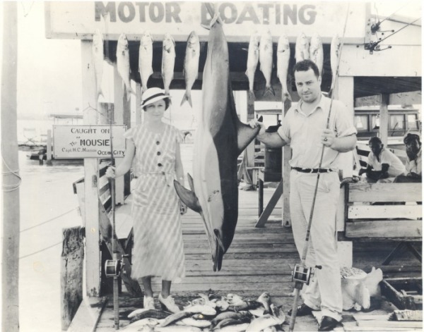
1934
Note the well-dressed crowd on the Boardwalk for the Fourth of July 1948 celebration.
1948
Title Text.

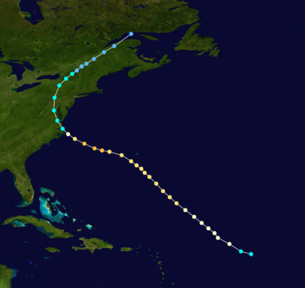
- 1933 Chesapeake–Potomac hurricane -
The 1933 Chesapeake-Potomac Hurricane was the 8th storm and third hurricane of the very active 1933 Atlantic hurricane season. The August storm formed in the central Atlantic, where it moved west-northwest. Aided by the warm ocean waters, the hurricane briefly reached Category 3 status on the Saffir-Simpson Hurricane Scale before making landfall along the Virginia/North Carolina coast as a Category 1 storm.
The hurricane caused severe damage along the East Coast of the United States. The state hardest hit by the storm was Virginia, where the center of circulation passed directly over Norfolk. The hurricane was the worst storm to strike Virginia until Hurricane Isabel of 2003. Elsewhere, the hurricane left damage across Maryland, Washington, D.C. and Delaware. In all, the hurricane caused $27.2 million dollars (1933 USD, $368.4 million 2005 USD) in damage and 30 fatalities.
The hurricane caused severe damage along the East Coast of the United States. The state hardest hit by the storm was Virginia, where the center of circulation passed directly over Norfolk. The hurricane was the worst storm to strike Virginia until Hurricane Isabel of 2003. Elsewhere, the hurricane left damage across Maryland, Washington, D.C. and Delaware. In all, the hurricane caused $27.2 million dollars (1933 USD, $368.4 million 2005 USD) in damage and 30 fatalities.
*Formed August 17, 1933
*Dissipated August 26, 1933 Highest
*winds 120 mph (195 km/h) (1-minute sustained)
*Lowest pressure 971 mbar (hPa; 28.67 inHg)
*Fatalities 18-30 direct
*Damage $27.2 million (1933 USD) $457 million (2009 USD)
Areas affected North Carolina, Virginia, Maryland, Washington, D.C., Mid-Atlantic States,Northeastern United States Part of the
1933 Atlantic hurricane season
Preparations
Hurricane warnings were issued on August 21. The warnings extended from Cape Hatteras to Boston. The next day the warnings were extended to Southport, North Carolina. Evacuations may or may not have taken place.
Impact
The Chesapeake-Potomac Hurricane was the most severe Atlantic hurricane to hit the East Coast since 1821. In all, the storm caused $27.2 million dollars (1933) dollars of damage and left 18-30 fatalities.
Aftermath
In Maryland the American Red Cross collected over $300 dollars (1933 USD, $4,063 2006 USD) in relief during the cleanup after the storm.
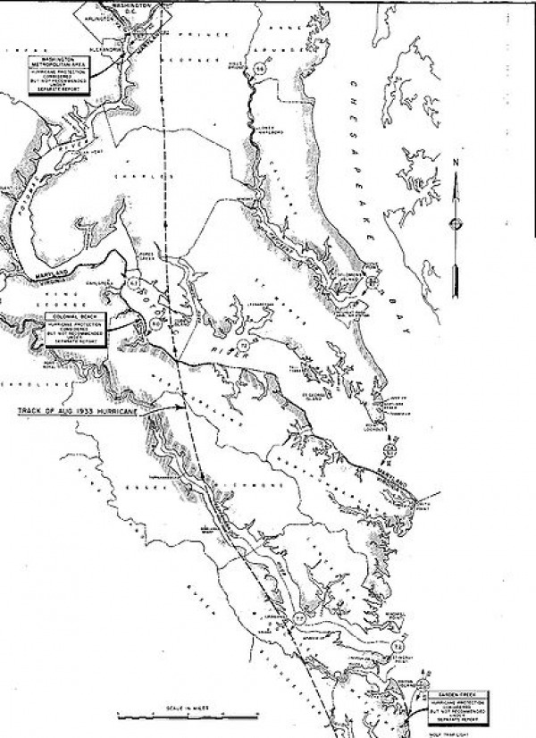
- Storm path -
- Track of the 1933 Hurricane across Virginia and Maryland. -
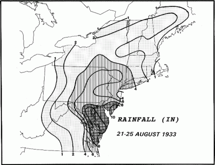
- 1933 hurricane rainfall across the Northeast -
- MID ATLANTIC -
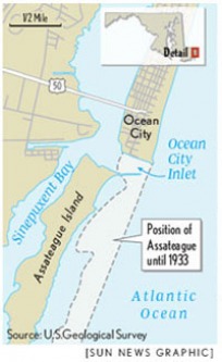
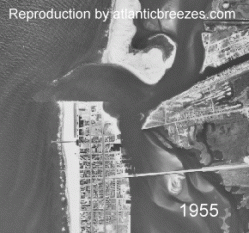
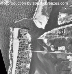
In Washington, D.C., the storm produced a storm surge of 11.3 feet (3.4 m), rainfall of 6.18 inches (152 mm) and winds of 50 mph (80 km/h). In Maryland, the hurricane caused $17 million dollars (1933 USD, $230 million 2005 USD) in damage to crops and buildings. The storm also destroyed a railroad bridge heading into Ocean City and created the Ocean City Inlet between the town and Assateague Island. The storm killed 13 people and 1,000+ animals.On the coast, the storm damaged or destroyed several wharves and fishing piers. In Delaware, the storm caused $150,000 dollars (1933 USD, $2.03 million 2005 USD) in damage but no deaths. Damage was also reported in New Jersey, although damage figures are unknown. At least 7 were reported dead. Offshore, the hurricane sank or badly damaged 100 boats and ships.
In Washington, D.C., the storm produced a storm surge of 11.3 feet (3.4 m), rainfall of 6.18 inches (152 mm) and winds of 50 mph (80 km/h). In Maryland, the hurricane caused $17 million dollars (1933 USD, $230 million 2005 USD) in damage to crops and buildings. The storm also destroyed a railroad bridge heading into Ocean City and created the Ocean City Inlet between the town and Assateague Island. The storm killed 13 people and 1,000+ animals.On the coast, the storm damaged or destroyed several wharves and fishing piers. In Delaware, the storm caused $150,000 dollars (1933 USD, $2.03 million 2005 USD) in damage but no deaths. Damage was also reported in New Jersey, although damage figures are unknown. At least 7 were reported dead. Offshore, the hurricane sank or badly damaged 100 boats and ships.
North Carolina and Virginia
In Cape Hatteras, North Carolina, winds up to hurricane force were reported. Damage in North Carolina was considered severe, with monetary damage estimated at $250,000 (1933 USD). In Virginia, a weather station in Norfolk recorded sustained winds of 56 mph (90 km/h), while Cape Henry reported a wind gust of 82 mph (132 km/h). Several tide gauges reported tides 7-9 feet above normal and a storm surge of 6-9 feet. The high tides and storm surge flooded much of downtown Norfolk and sank ten ships. Elsewhere along the coast, the hurricane's storm surge caused severe beach erosion. On Cedar Island, the hurricane destroyed a hotel and several other buildings. In Surry County, the storm surge from the hurricane caused the James River to overflow its banks and sweep away a ferry pier. The York River also rose 5-8 feet above flood stage. The flooding along the York River caused severe damage in Gloucester County. Further inland, strong winds knocked out power and phone service in Alexandria, while flooding knocked out roads and flooded a Ford Motor Company plant.
In Cape Hatteras, North Carolina, winds up to hurricane force were reported. Damage in North Carolina was considered severe, with monetary damage estimated at $250,000 (1933 USD). In Virginia, a weather station in Norfolk recorded sustained winds of 56 mph (90 km/h), while Cape Henry reported a wind gust of 82 mph (132 km/h). Several tide gauges reported tides 7-9 feet above normal and a storm surge of 6-9 feet. The high tides and storm surge flooded much of downtown Norfolk and sank ten ships. Elsewhere along the coast, the hurricane's storm surge caused severe beach erosion. On Cedar Island, the hurricane destroyed a hotel and several other buildings. In Surry County, the storm surge from the hurricane caused the James River to overflow its banks and sweep away a ferry pier. The York River also rose 5-8 feet above flood stage. The flooding along the York River caused severe damage in Gloucester County. Further inland, strong winds knocked out power and phone service in Alexandria, while flooding knocked out roads and flooded a Ford Motor Company plant.
1933 hurricane rainfall across the Northeast In Fairfax County and Loudoun County, flooding caused severe damage to farms and crops. Richmond sustained $250,000 dollars (1933 USD, $33.8 million 2005 USD) in damage, mainly to trees and roofs. In all the hurricane killed 18 people in Virginia and left $10 million dollars (1933 USD).
Statistics
The Chesapeake-Potomac Hurricane held the record of being the earliest eighth Atlantic tropical cyclone to form before September, a record held until 2005, when Tropical Storm Harvey formed on August 2.
The 1933 hurricane's track and impact was similar to Hurricane Isabel in 2003. Both storms struck northeastern North Carolina as a Category 1 or 2 hurricane, and both left severe damage in southeastern Virginia. The wind speed and pressure at landfall brought by the 1933 storm was tied by Hurricane Isabel in 2003. However, the record tidal surge was broken by Isabel.
The 1933 hurricane's track and impact was similar to Hurricane Isabel in 2003. Both storms struck northeastern North Carolina as a Category 1 or 2 hurricane, and both left severe damage in southeastern Virginia. The wind speed and pressure at landfall brought by the 1933 storm was tied by Hurricane Isabel in 2003. However, the record tidal surge was broken by Isabel.
The storm's wind and waves tore out long stretches of the Boardwalk. It was rebuilt to stand taller, hopefully above future storm waves.
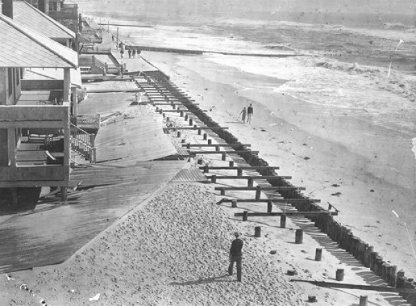
Storm survivors survey the damage in Ocean City. Described in the American Meteorological Society's August 1933 weather review as "one of the most severe storms that has ever visited the Middle Atlantic Coast," the slow-moving weather mass dumped 10 inches of rain a day for nearly a week, even before wind gusts as high as 80 mph and a 7-foot tide arrived. (Baltimore Sun file photo / August 18, 2008)
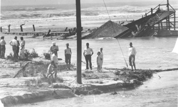
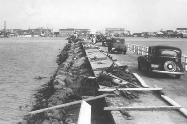
The storm severed rail and road ties to the island. The elevated causeway was wrecked.
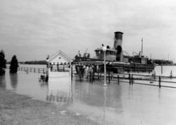
Sinepuxent Bay
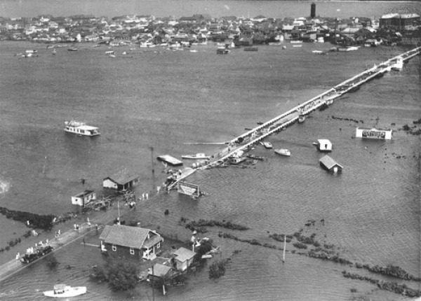
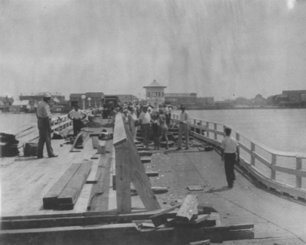
Sightseers watch repair work to the bridge into Ocean City following the hurricane of August 23, 1933 -- one of the worst storms ever to strike the resort.
ocean city storm
Ocean City Md., 1933
Ocean City Md., 1933
Great Storm of 1933
Cleanup
Causeway, Ocean City
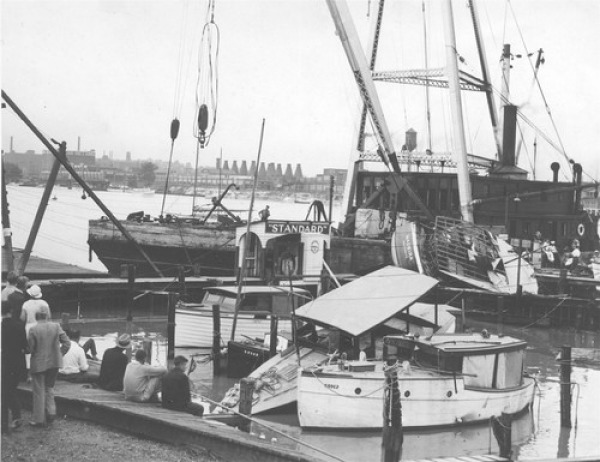
Baltimore Harbor
The interchange where the causeway connects with Ocean City's streets was still awash days after the storm.
1933 STORM Ankle-deep
- SHIFTING SANDS -
stinkybeach 1933 Shifting Sands of Time
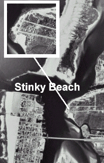
stinkybeach
1964
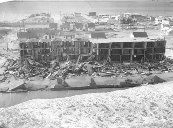
The so-called "Storm of the Century" slammed into the Atlantic Coast from North Carolina to New England on March 5-9,1962.
Also known as the "Ash Wednesday Storm," it devastated many communities along the Eastern Shore, especially Ocean City, Rehoboth, Bethany, Fenwick, Dewey Beach and Chincoteague. Ocean City alone suffered almost $7 million in damage, experiencing more wreckage than from the Great Storm of 1933, which cut the inlet.
The Baltimore Sun did an excellent job documenting the destruction and rebuilding along the Delmarva coast. The photographic team was led by A. Aubrey Bodine, who spent much of his time after the storm on the Eastern Shore capturing images of the storm's aftermath and the subsequent recovery. This work was published in a Sunday Sun Magazine special issue on April 15, 1962, as well as a 52-page booklet that contained many previously unpublished photos. Other photographers from the Sun's photo staff who covered the storm were Clarence Garrett (who took the shot above), William Mortimer, Ralph Robinson and William Burton.
You can find a gallery of their work at this link.
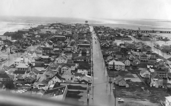
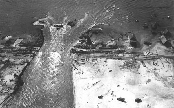
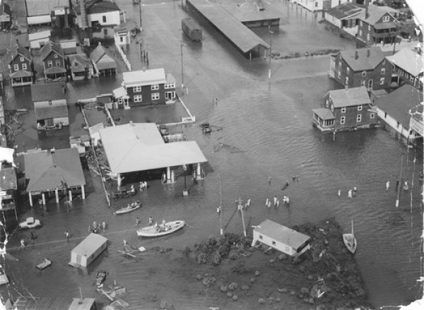
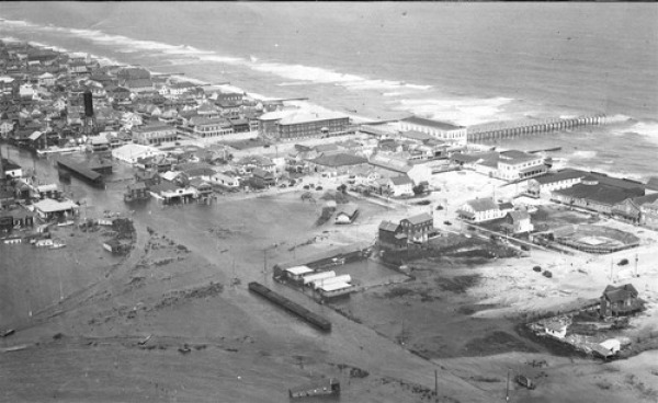
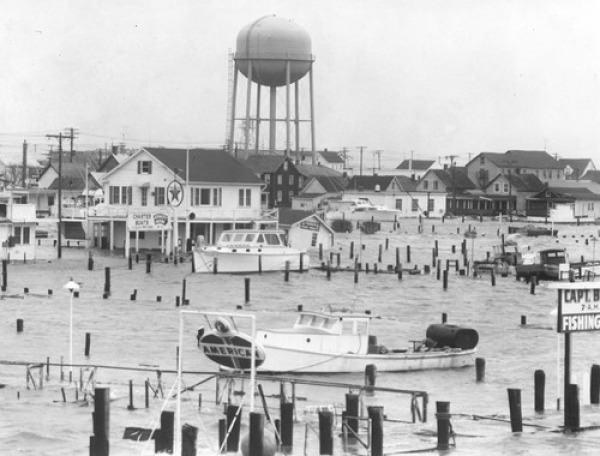
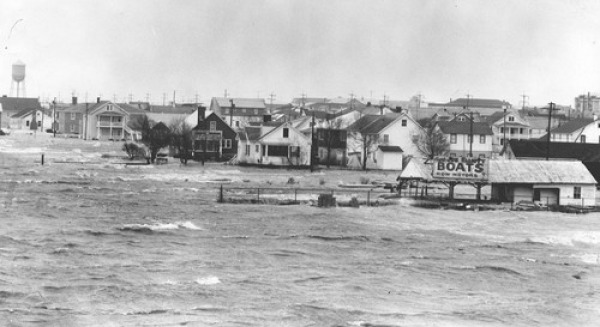
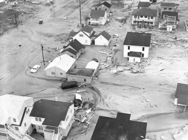
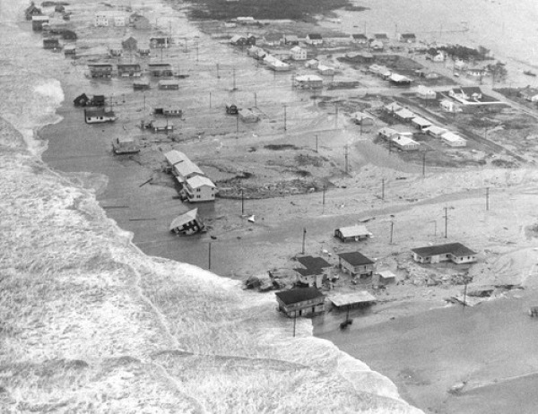
During March 6 and 7, 1962, a storm raged along the East Coast from the Outer Banks of North Carolina to Long Island, N.Y. It caused extensive damage. At the time, property loss was placed at nearly $200 million. Aerial view of Ocean City at the height of flooding.
Extensive flooding (Baltimore Sun photo by Clarence B. Garrett) The storm is considered worse than the hurricane that hit the seaside town in 1933. Strong winds and an especially high tide caused flooding in Ocean City and along the coast.
1962
Rescue (Baltimore Sun photo by Clarence B. Garrett) Rescue workers transfer an Ocean City resident from a truck to a bus on the bridge across Sinepuxent Bay. Forty people were killed on the East Coast and more
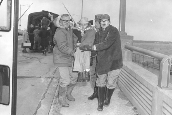
1962
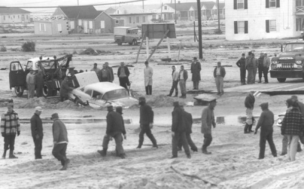
Once flood waters receded, prison work crews were brought in from the Poplar Hill Labor Camp in Quantico, Md., to help with cleanup.
1962
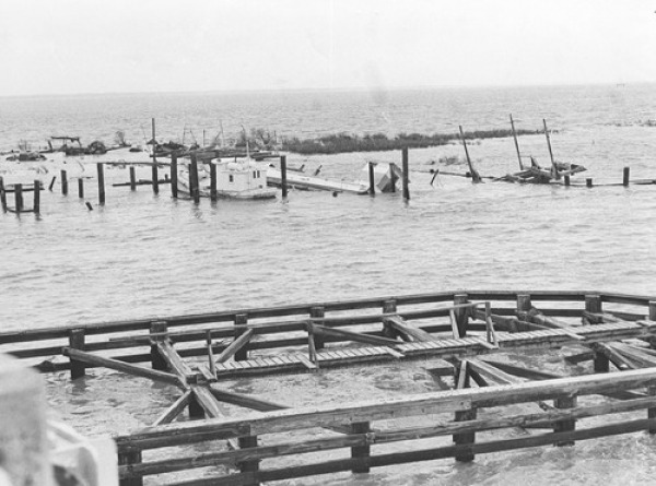
Marine railway and repair shed
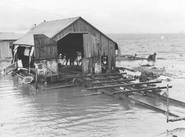
1962
Flooding from the storm was made worse by the moon phase and tides.
1962
The winter population was about 1,500. Two-thirds left town in the evacuation.
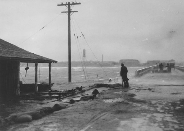
The view southward on Philadelphia Avenue. The sea was driven into the city by gale gusts that reached hurricane force.
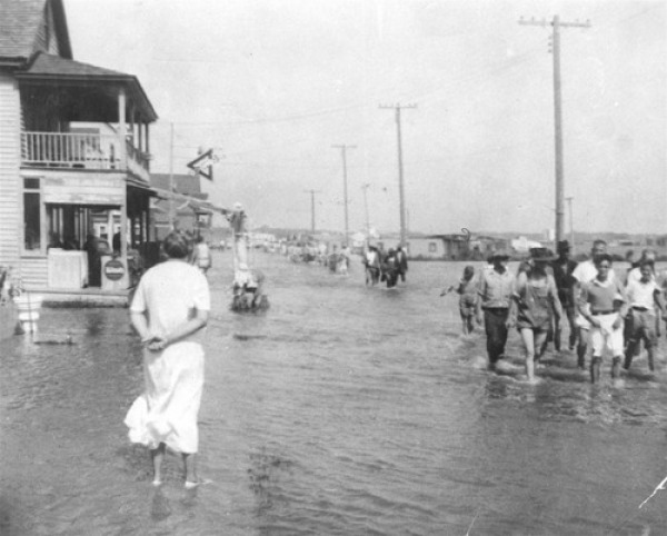
Flooded Ocean City streets
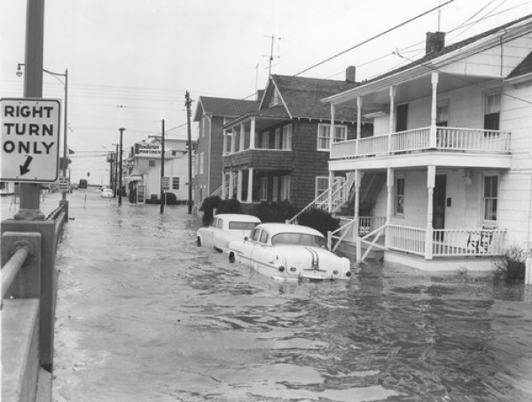
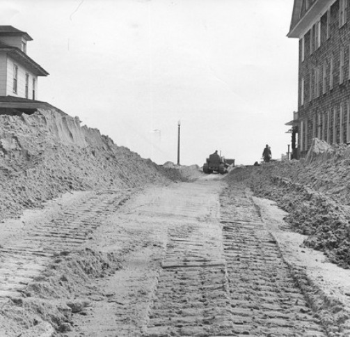
When the floodwaters finally receded, streets and lawns were buried in sand and debris.
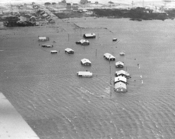
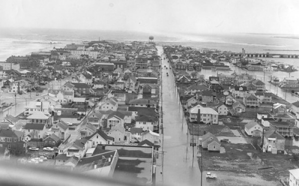
An aerial view of Ocean City shows extensive damage done by high tides and stiff winds.
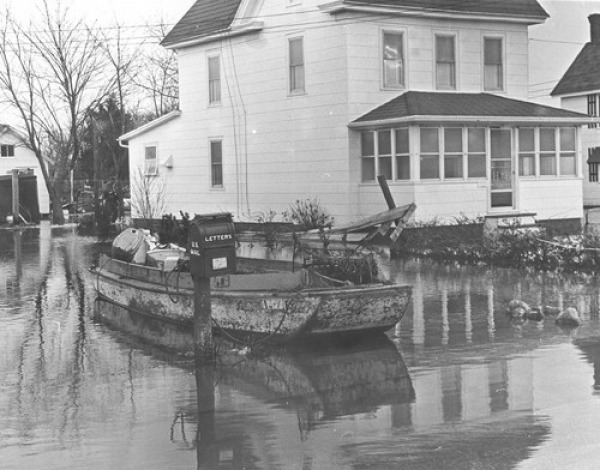
Boats were smashed, sunk and washed up in streets and lawns. A crab boat in a flooded driveway on Chincoteague Street in Ocean City.
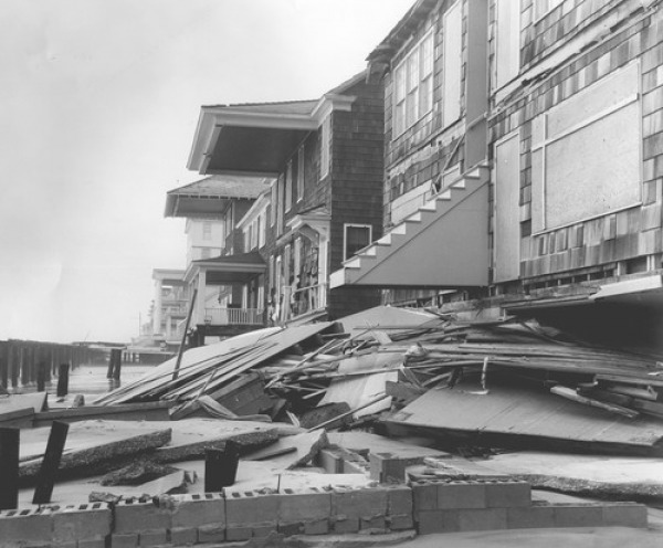
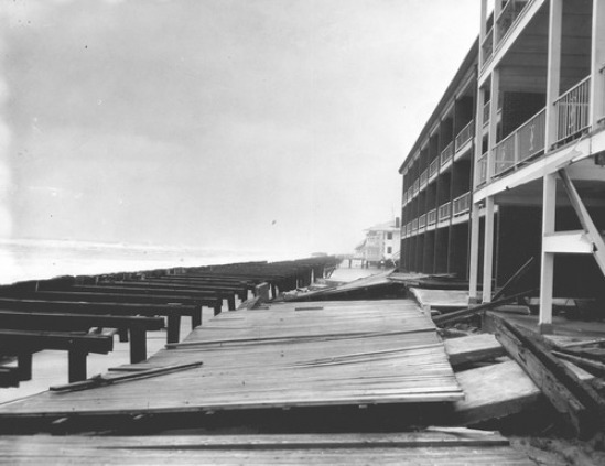
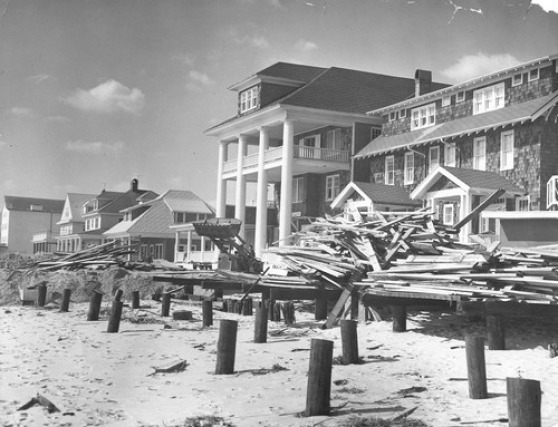
Portions of the Ocean City Boardwalk were pushed off their pilings, slamming into hotels and other buildings.
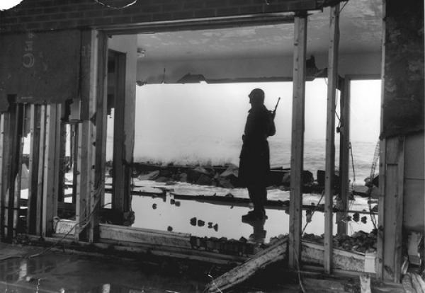
A National Guardsman looks to the ocean as he stands watch at the Oceanic Motel. Eventually, 300 guardsmen were on hand to prevent looting and provide around-the-clock security. There were no major thefts reported.
Harold Rayne Jr., his daughter, Sally, 11; Earl Simpson, 12, and Bill Simpson, 7, shovel sand from a street in Ocean City.
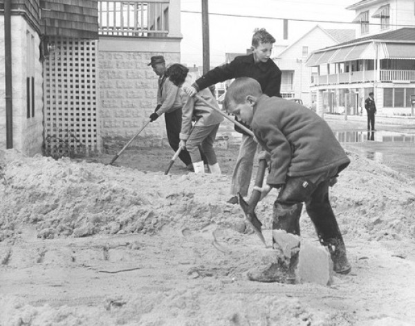
The sand blanketed the town, burying everything from cars to houses. Bulldozers move sand back toward the beach at 4th Street.
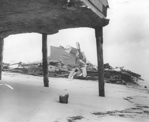
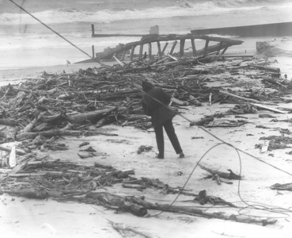
A section of Ocean City where a home once stood and driftwood at 77th Street.
Aerial view of a destroyed oceanfront motel in Ocean City.
A portion of the Ocean City Boardwalk ripped from its pilings by the storm.
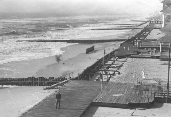
Cleanup in front of the Lankford Hotel in Ocean City. The State Roads Commission brought about 150 pieces of equipment to Ocean City to start the cleanup.
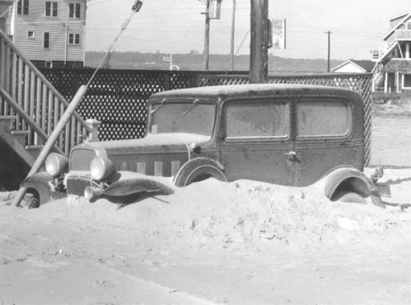
Wrecker crews attempt to free a half-buried car.
Title Text.
Title Text.
